
What do contours represent in a toposheet? How do the contour lines help to identify the different geomorphic features of an area? Explain with neat diagrams. IAS 2024, 15 Marks
What do contours represent in a toposheet? How do the contour lines help to identify the different geomorphic features of an area? Explain with neat diagrams. IAS 2024, 15 Marks

Introduction:
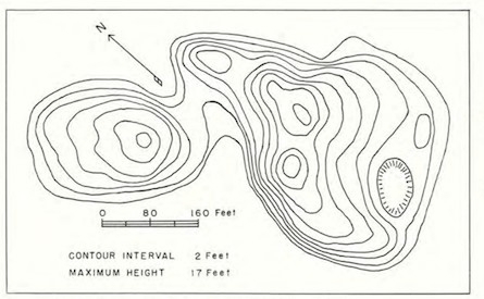
Contours in a topographic map represent lines connecting points of equal elevation. These lines help to visualize the shape and elevation of the land surface.
What do contours represent in a toposheet?
Contours are fundamental elements of a toposheet, representing the three-dimensional landscape in two dimensions through lines that indicate elevation.
- Definition of Contours:
- Contour lines are imaginary lines on a map that join points of the same elevation above a reference point, usually sea level.
- Purpose:
- They depict the topography of an area, including elevation, slope, and relief.
- Serve as a guide to understanding the terrain's shape and features.
- Rules of Contour Representation:
- Contour lines never cross, as a point cannot have two different elevations.
- Closely spaced contours indicate steep slopes, while widely spaced ones indicate gentle slopes.
- Closed contours often represent hills (elevation increasing inward) or depressions (elevation decreasing inward).
How do contour lines help identify different geomorphic features?
Contour lines are essential for interpreting the shape and nature of landforms. By analyzing the patterns and spacing of contours, various geomorphic features can be identified:
a. Hills and Mountains
- Closed, circular, or oval contour lines with increasing elevation toward the center.
- Tightly packed contours indicate steep slopes of a mountain.
b. Valleys and Rivers
- V-shaped contours pointing uphill indicate valleys.
- The sharp end of the "V" usually points toward higher elevation, showing the flow direction of water.
c. Ridges
- U-shaped contours pointing downhill represent ridges.
- These typically indicate areas of higher ground extending laterally.
d. Plateaus
- Contours that form a closed loop with a significant flat area within indicate a plateau.
- The elevation remains relatively consistent across the central region.
e. Depressions or Basins
- Closed contour lines with decreasing elevation toward the center.
- Hachure marks inside the contour indicate a depression.
f. Cliffs
- Very tightly spaced or overlapping contours suggest vertical or near-vertical terrain.
g. Saddle
- Low points between two higher elevation areas, shown by two opposing "U" or "V" shapes.
Conclusion:
Contour lines in a topographic map are essential for understanding the elevation and geomorphology of an area. By interpreting these lines, one can identify various landforms and navigate through the terrain effectively.