
Discuss the intensity and magnitude scale commonly used to assess seismic damage. Write a note on the global distribution pattern of earthquake. Mark the different seismic zones of India on the given map and discuss about them. IAS 2024, 20 Marks
Discuss the intensity and magnitude scale commonly used to assess seismic damage. Write a note on the global distribution pattern of earthquake. Mark the different seismic zones of India on the given map and discuss about them. IAS 2024, 20 Marks

Introduction:
- Seismic damage is often assessed using intensity and magnitude scales to determine the impact of an earthquake on structures and infrastructure. These scales provide valuable information for emergency response and recovery efforts.
- Earthquakes are natural disasters that occur all over the world, but they are not evenly distributed. The global distribution pattern of earthquakes is influenced by tectonic plate boundaries and geological features.
Intensity Scale for Assessing Seismic Damage
The intensity scale measures the effects and severity of an earthquake based on observed impacts on people, buildings, and the natural environment. It is qualitative and describes how the earthquake feels and the damage it causes.
- Modified Mercalli Intensity (MMI) Scale:
- Most commonly used scale for measuring earthquake intensity.
- Ranges from I (not felt) to XII (total destruction).
- Assesses damage to structures, human perception, and environmental changes.
- Example:
- Level I: Barely perceptible.
- Level VI: Felt by all, some structural damage.
- Level XII: Total destruction, ground deformation.
- Rich Detail in Observations:
- Subjective based on eyewitness accounts.
- Useful for understanding localized impact.
- Does not directly correlate with energy release but complements magnitude measurements.
Magnitude Scale for Assessing Seismic Damage
Magnitude measures the energy released at the earthquake's source. It is quantitative and provides a uniform scale to compare earthquakes globally.
- Richter Scale:
- Developed by Charles F. Richter in 1935.
- Measures the amplitude of seismic waves recorded by seismographs.
- Logarithmic scale: Each unit increase represents tenfold wave amplitude and 32 times energy release.
- Suitable for small to moderate earthquakes.
- Moment Magnitude Scale (Mw):
- More accurate and widely used than the Richter Scale.
- Measures total seismic energy release.
- Considers fault slip, area of rupture, and rigidity of rocks.
- Effective for assessing large-scale earthquakes.
- Comparison with Intensity:
- Magnitude provides a global, quantitative energy estimate.
- Intensity reflects localized effects and variations in damage.
Global Distribution Pattern of Earthquakes
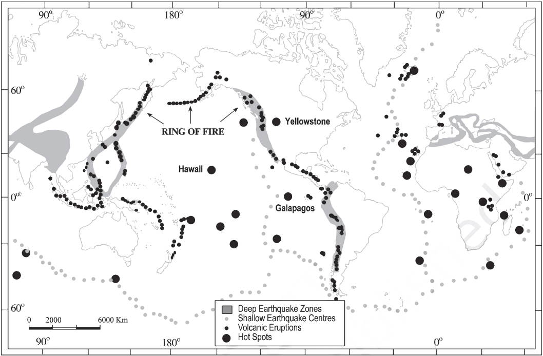
Earthquakes are not randomly distributed; their occurrence is influenced by tectonic plate boundaries, geological structures, and other localized conditions. The global distribution can be categorized as follows:
A. Plate Boundaries
- Convergent Boundaries:
- Found in regions like the Pacific Ring of Fire.
- Subduction zones, such as the Andes and Japan, experience deep and intense earthquakes.
- Divergent Boundaries:
- Common at mid-oceanic ridges (e.g., Mid-Atlantic Ridge).
- Generally, shallow and less destructive earthquakes occur here.
- Transform Boundaries:
- Found in regions like the San Andreas Fault.
- Characterized by shallow and often destructive earthquakes.
B. Intraplate Earthquakes
- Occur within tectonic plates away from boundaries.
- Examples include the New Madrid Seismic Zone in the USA and stable shield areas like Peninsular India.
C. Volcanic Activity
- Associated with active volcanic zones, e.g., Iceland and the Pacific islands.
- Earthquakes here are linked to magma movement.
D. Human-Induced Seismicity
- Caused by mining, reservoir-induced seismicity, or geothermal energy extraction.
- Examples include the Koyna Dam area in India and the Groningen gas fields in the Netherlands.
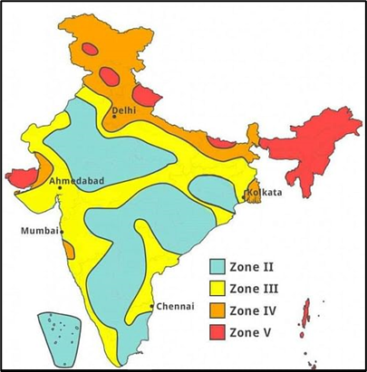
Seismic Zones of India
India's seismic zones are categorized based on the earthquake risk and intensity, divided into four main zones (Zone II to Zone V). Here's a breakdown:
A. Zone V
- Most seismically active.
- Intensity: High (VIII and above on the Modified Mercalli Intensity scale).
- Includes regions like the Himalayas, Northeast India, parts of Jammu & Kashmir, and the Andaman-Nicobar Islands.
- Example: 2005 Kashmir Earthquake.
B. Zone IV
- Intensity: Severe (VII to VIII).
- Includes parts of Himachal Pradesh, Uttarakhand, parts of Bihar, and Delhi.
- Example: Bihar-Nepal Earthquake (1934).
C. Zone III
- Moderate to high seismic risk.
- Includes regions like Gujarat, Maharashtra, and parts of the Gangetic Plains.
- Example: Bhuj Earthquake (2001).
D. Zone II
- Low-risk zone.
- Stable shield areas like Peninsular India.
- Example: Rare minor tremors.
Seismic Zones of India
Conclusion:
Intensity and magnitude scales are essential tools for assessing seismic damage and understanding the impact of earthquakes on communities. By using these scales, researchers and emergency responders can better prepare for future seismic events and mitigate the effects of earthquakes on vulnerable populations. The global distribution pattern of earthquakes is influenced by tectonic plate boundaries, while the seismic zones of India are classified based on the intensity and frequency of earthquakes in each region.